← The Wingmakers Ways · Astronomy & Exoplanets
Archived page · Checkable
Mars
Mars.html · captured from wingmakers.co.nz
Mars
 Mars is the fourth planet from the Sun and is commonly referred to as the Red Planet. The rocks, soil and sky have a red or pink hue.
Universe
Solar System Sun
Mercury
Venus
Earth
Mobius
Mars
Jupiter
Saturn
Uranus
Neptune
Pluto
2004 DW
Quaoar
Sedna
2002 AW197
2003 UB313
Comets
Meteorites
Asteroids
Planetary Moons
Earth
The Moon
Saturn
Titan
Tethys
Enceladus
Dione
Extrasolar planets
Star Systems
Terrestrial Planet
Mars Statistics
Star System : Meridian Solar System
Mass (kg) : 6.421e+23
Mass (Earth = 1) : 1.0745e-01
Equatorial radius (km) : 3,397.2
Equatorial radius (Earth = 1) : 5.3264e-01
Mean density (gm/cm^3) : 3.94
Mean distance from the Sun (km) : 227,940,000
Mean distance from the Sun (Earth = 1) : 1.5237
Rotational period (hours) : 24.6229
Rotational period (days) : 1.025957
Equatorial surface gravity (m/sec^2) : 3.72
Equatorial escape velocity (km/sec) : 5.02
Visual geometric albedo : 0.15
Magnitude (Vo) : -2.01
Minimum surface temperature : -140°C
Mean surface temperature : -63°C
Maximum surface temperature : 20°C
Atmospheric pressure (bars) : 0.007
Mars Orbit
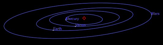
Mars Orbital Statistics
Orbital period (days) 686.98
Mean orbital velocity (km/sec) 24.13
Orbital eccentricity 0.0934
Tilt of axis (degrees) 25.19
Orbital inclination (degrees) 1.850
Interstellar Card
Mars's rotation produces a day just a little longer than an Earth day. However, it's most distant orbit around the Sun takes almost two Earth years and is also significantly elliptical ("eccentric"). As as result, surface temperature varies by about 30 °C (86 °F) between its closest and farthest approaches to the Sun (perihelion and aphelion).
Mars Interior
The interior of Mars appears to contain a dense core of about 3,400 km (2,200 miles) in diameter, a molten rocky mantle somewhat denser than the Earth's, and a thin crust. The crust is about 80 km (50 miles) thick in the southern hemisphere but only about 35 km (22 miles) thick in the north. Mars' relatively low density compared to the other terrestrial planets indicates that its core probably contains a relatively large fraction of sulfur in addition to iron (i.e., as iron sulfide).
The current understanding of the interior of Mars suggests that it can be modeled with a thin crust, similar to Earth's, a mantle and a core. Using four parameters, the Martian core size and mass can be determined. However, only three out of the four are known and include the total mass, size of Mars, and the moment of inertia. Mass and size was determined accurately from early missions. The moment of inertia was determined from Viking lander and Pathfinder Doppler data, by measuring the precession rate of Mars. The fourth parameter, needed to complete the interior model, will be obtained from future spacecraft missions. With the three known parameters, the model is significantly constrained. If the Martian core is dense (composed of iron) similar to Earth's or SNC meteorites thought to originate from Mars, then the minimum core radius would be about 1300 kilometers. If the core is made out of less-dense material such as a mixture of sulfur and iron.
Mars Atmospheric Composition
Carbon Dioxide (C02) : 95.32%
Nitrogen (N2) : 2.7%
Argon (Ar) : 1.6%
Oxygen (O2) : 0.13%
Carbon Monoxide (CO) : 0.07%
Water (H2O) : 0.03%
Neon (Ne) : 0.00025%
Krypton (Kr) : 0.00003%
Xenon (Xe) : 0.000008%
Ozone (O3) : 0.000003%
Martian Atmosphere
Today, what little atmosphere Mars is able to hold on to is composed primarily of carbon dioxide (over 95 percent) with small amounts of other gases (including 2.7 percent nitrogen, 2.7 percent argon, but only 0.13 percent oxygen). Barometric pressure varies slightly between about 7 and 11 millibars in the northern and southern hemispheres as carbon dioxide freezes out to form an immense polar cap at the pole then in Winter, which evaporates in Spring. In contrast, the average atmospheric pressure on Earth is about a hundred times greater at around 1,000 millibars. However, Mars' atmosphere is thick enough to support strong winds and vast dust storms that can blanket the entire planet for months. Its thin atmosphere produces a greenhouse effect that is only enough to raise surface temperature by 5 degrees Celsius (2.8 °F), much less than what occurs on Venus and Earth.
Martian Clouds
Although small, this is thought to be enough to allow water ice to be frozen into the surface of the planet. With so little water, clouds are rarely seen in the Martian sky. The possible role in the past of liquid water in forming the dry river beds which we can see is still unknown, particularly because water ice is not plentiful on the surface of the planet.
Unlike the Earth, where clouds are found around the entire globe, on Mars, clouds seem to be plentiful only in the equatorial region, as shown in this Hubble telescope image. This may be because water of Mars may only be found at equatorial regions.
Clouds On Mars
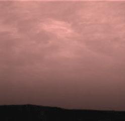
This is the first color image ever taken from the surface of Mars of an overcast sky. Featured are pink stratus clouds coming from the northeast at about 15 miles per hour (6.7 meters/second) at an appoximate height of ten miles (16 kilometers) above the surface. The clouds consist of water ice condensed on reddish dust particles suspended in the atmosphere. Clouds on Mars are sometimes localized and can sometimes cover entire regions, but have not yet been observed to cover the entire planet. The image was taken about an hour and forty minutes before sunrise by the Imager for Mars Pathfinder (IMP) on Sol 16 at about ten degrees up from the eastern Martian horizon.
Liquid Water on Mars
A series of troughs and layered mesas in the Gorgonum Chaos region of the Martian southern hemisphere appears in the chaotic terrain. Gullies proposed to have been formed by seeping ground water emanate from a specific layer near the tops of trough walls, particularly on south-facing slopes. Such a layer is called an aquifer, and this one appears to be present less than a few hundred meters (few hundred yards) beneath the surface in this region. This image was taken by the Mars Global Surveyor camera on January 22, 2000.
Surface Of Mars
This view from Spirit's panoramic camera is assembled from frames acquired on Martian days, or sols, 672 and 673 (Nov. 23 and 24, 2005) from the rover's position near an outcrop called "Seminole." The view is a southward-looking portion of a larger panorama still being completed. This approximately true-color view is a composite of images shot through three different filters, admitting light of wavelengths 750 nanometers, 530 nanometers and 430 nanometers. 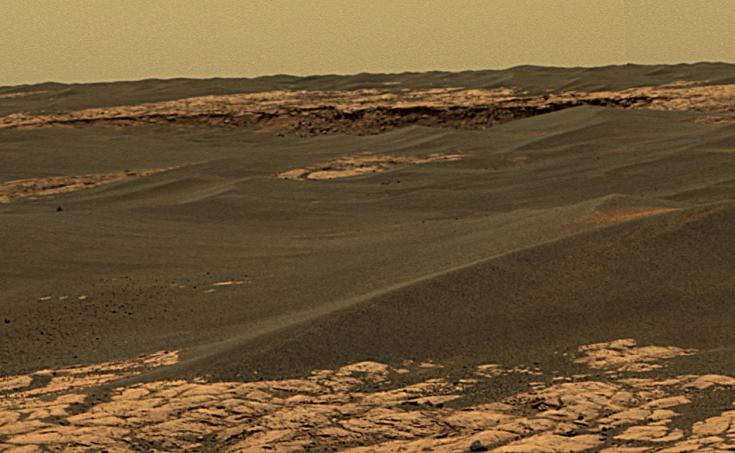
The center upper portion of this image shows a portion of the rim of "Erebus Crater" in the Meridiani Planum region of Mars. This approximately true-color view from the panoramic camera on NASA's Mars Exploration Rover Opportunity is a composite of frames acquired on the rover's 657th Martian day, or sol, (Nov. 28, 2005). This is a small portion of a large panorama. Other portions of the panorama were still being shot three sols later. This view is a composite of separate images taken through the camera's 750-nanometer, 530-nanometer and 430-nanometer filters.
Olympus Mons
The largest volcano in the solar system is Olympus Mons, shown in the image to the left. Olympus Mons is a Martian shield volcano. The altitude of Olympus Mons is three times the altitude of the largest peak on Earth, Mt. Everest, and is as wide as the entire chain of Hawaiian Islands. Measurements returned by Mars Global surveyor demonstrate the unbelievable size of Olympus Mons. Olympus Mons is a very large volcano for a body as small as Mars. Mars is three times smaller than the Earth! The size of Olympus Mons suggests something special about the surface of Mars and how Mars cooled over time.
A Misty Sunrise Over Olympus Mons 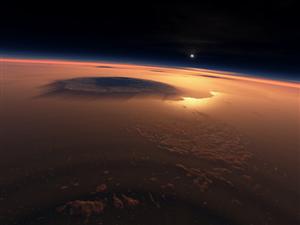
Mars has several other *very* large volcanoes. Some of them are located on top of a big bulge in the side of Mars called the Tharsis Ridge. The volcanoes were formed in a manner similar to that in which the Hawaiian Islands came into being on Earth, namely from a hot balloon of material which rises from the deep interior of the planet and forms land on the surface. The size of these volcanoes suggests that, Mars had already cooled off and formed a crust thick enough to hold up the large volcanoes without allowing them to sink as they formed.
This image was taken at the Viking Lander 1 site, using camera 2. The lander's footpad is visible in the lower right. This scene shows a rocky field with trenches in the foreground (just below center) dug by the sampler arm. Patches of drift material and possibly bedrock are visible further from the Lander.
Dunefield
This image shows several dune types which are found in the north circumpolar dunefield. This thumnail image shows a section of transverse dunes. The full image has a field of traverse dunes on the left and barchan dunes on the right with a transition zone inbetween. Transverse dunes are oriented perpendicular to the prevailing wind direction. They are long and linear, and frequently join their neighbor in a low-angle "Y" junction. Barchan dunes are crescent-shaped mounds with downwind-pointing horns. These dunes are comparable in size to the largest dunes found on the Earth.
Martian Sunset
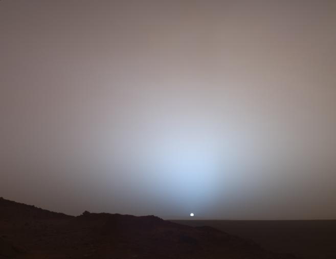
With Pupple Clouds
On May 19th, 2005, NASA's Mars Exploration Rover Spirit captured this stunning view as the Sun sank below the rim of Gusev crater on Mars. This Panoramic Camera (Pancam) mosaic was taken around 6:07 in the evening of the rover's 489th martian day, or sol. Spirit was commanded to stay awake briefly after sending that sol's data to the Mars Odyssey orbiter just before sunset. This small panorama of the western sky was obtained using Pancam's 750-nanometer, 530-nanometer and 430-nanometer color filters. This filter combination allows false color images to be generated that are similar to what a human would see, but with the colors slightly exaggerated. In this image, the bluish glow in the sky above the Sun would be visible to us if we were there, but an artifact of the Pancam's infrared imaging capabilities is that with this filter combination the redness of the sky farther from the sunset is exaggerated compared to the daytime colors of the martian sky. Because Mars is farther from the Sun than the Earth is, the Sun appears only about two-thirds the size that it appears in a sunset seen from the Earth. The terrain in the foreground is the rock outcrop "Jibsheet", a feature that Spirit has been investigating for several weeks (rover tracks are dimly visible leading up to "Jibsheet"). The floor of Gusev crater is visible in the distance, and the Sun is setting behind the wall of Gusev some 80 km (50 miles) in the distance
Mars Over Moon
Ron Wyman of Tampa, Fla., captured this crisp picture of Mars emerging from behind the Moon with an 8-inch telescope and a digital camera. Mars was briefly occulted - hidden from view - by Earth's Moon early on July 17.
The Plane of the Ecliptic
The Plane of the Ecliptic is illustrated in this Clementine star tracker camera image which reveals (from right to left) the Moon lit by Earthshine, the Sun's corona rising over the Moon's dark limb, and the planets Saturn, Mars, and Mercury.
The ecliptic plane is defined as the imaginary plane containing the Earth's orbit around the Sun. In the course of a year, the Sun's apparent path through the sky lies in this plane. The planetary bodies of our solar system all tend to lie near this plane, since they were formed from the Sun's spinning, flattened, proto-planetary disk.
The snapshot above nicely captures a momentary line-up looking out along this fundamental plane of our solar system.
Earth From Mars
Date: 03.08.2004
This is the first image ever taken of Earth from the surface of a planet beyond the Moon. It was taken by the Mars Exploration Rover Spirit one hour before sunrise on the 63rd Martian day, or sol, of its mission.
The image is a mosaic of images taken by the rover's navigation camera showing a broad view of the sky, and an image taken by the rover's panoramic camera of Earth. The contrast in the panoramic camera image was increased two times to make Earth easier to see.The inset shows a combination of four panoramic camera images zoomed in on Earth. The arrow points to Earth. Earth was too faint to be detected in images taken with the panoramic camera's color filters.
Satellites of Mars
 Phobos
  Deimos
Orbits Of Phobos And Deimos
Reflections Of The Heart - By Darryn John Murphy

Published by First Edition Publishers
Book Title - Reflections of the Heart
Author - Darryn John Murphy
ISBN 978-1-877479-28-1
192 pages
20cm x 14cm soft cover
Published March 2008
Reflections of the Heart - Click Here
In Reflections Of The Heart, Darryn shares a personal collection of candid and open hearted poems. His honest and sincere approach is a celebration of the most important thing in life - Love